
MAPS.ME
By Henk Grent, Mark Haakman, Frenk van Mil, Casper Schröder.

Table of Contents
- Introduction
- Stakeholders
- Pull Request Analysis
- Integrators
- Context View
- Development view
- Information View
- Technical Debt
- Conclusions
- References
- Appendices
Introduction
MAPS.ME is an offline map navigation app developed for Android and iOS devices, built on top of crowd-sourced OpenStreetMap data. In November 2014 the app was acquired by the Mail.Ru group as part of the My.com brand. The application was originally closed source but opened to the public as of September 2015.
The purpose of this chapter is to assess the quality of MAPS.ME as an open source project on the basis of a software architecture standpoint, by analyzing several aspects such as the integration process, context, structure, and technical debt.
This chapter provides an overview of the MAPS.ME project. First, the chapter identifies the stakeholders involved. Next, the chapter describes the pull request procedure of the project and the integrators involved in this process. Furthermore, a context view, development view, and information view describe the architecture and design. The last part contains an analysis of the technical debt identified.
Stakeholders
By identifying the stakeholders related to MAPS.ME it is easier to choose priorities and identify potential constraints. Functioning mainly as a mobile app, MAPS.ME relies strongly on the size of their user base and the companies this userbase attracts. Descriptions of stakeholders are inspired by Rozanski and Woods [25].
Users
MAPS.ME’s main feature of interest for end-users is its offline functionality. MAPS.ME provides high-quality, crowd-sourced maps for free. According to the MAPS.ME partners page [17], their audience consists out of people between the ages of 18 - 35, who are recreational travelers or business travelers.
Support staff
Support to other stakeholders is offered by means of e-mail contact and an online FAQ and knowledge base [18]. The support staff is assumed to be employed by MAPS.ME.
Suppliers
Supplier stakeholders build and/or supply the hardware, software, or infrastructure on which the system runs. There are a large number of external software dependencies. Two major stakeholders are Qt and C++. These dependencies are further identified in the context view. The app is deployed on both iOS and Android. As a result, they are dependent on Android and iOS. The terms and conditions of these stores [7; 2] can strongly influence the design choices MAPS.ME can make. Although the server focusses on offline navigation, it still requires OpenStreetMap to update the maps every once in a while.
Developers
The original MAPS.ME design and implementation were done by four people [13]. None of these developers appear to be contributing much, if any, code at this point [6]. Currently, there is a core team working for My.com (the owner company), situated in their office in Moscow, Russia.
After 2015, people we identified as most important developers are bykoianko, maksimandrianov, mpimenov, and rokuz. These developers seem to have more power than most other developers and will be further elaborated upon in the Integrators section.
Testers
Timofey Danshin has been doing tests and automation for the Mail.Ru Group since Dec 2015. However, he does not appear to be focused on MAPS.ME. Earlier in the project, there was no dedicated tester. Every contributor/maintainer is expected to provide test code for added features, according to the documentation. However, this requirement is rarely carried out in practice.
Missing roles
The other roles described in Rozanski and Woods [25], namely system administrators, acquirers, assessors, communicators, maintainers, production engineers and could not be identified. It is likely that these roles are either filled by someone from the Mail.ru group or are ignored completely. Another possibility is that integrators fill these roles, however, this is not clear from their GitHub activity.
Other stakeholders
Other stakeholders include stakeholders that were not mentioned by Rozanski and Woods [25], but which are still important entities that can influence MAPS.ME’s position.
Competitors
Competitors include software products produced by other companies or developers which offer similar functionality. Software products freely providing access to world maps are common. Notable are Google Maps and Apple Maps. Both of these competitors offer limited offline access to maps on mobile devices.
GitHub contributors
GitHub contributors add to the project by creating issues, pull request, and reviewing pull requests. These contributors can fulfill a similar role as the developers. However, they are less informed as they cannot easily integrate with the core development team. They are also less powerful, as they need explicit approval from developers in the MAPS.ME core team.
Funders
Funders include any party that provides conditional or unconditional revenue to one or more contributors of MAPS.ME. There are a number of sources of income. The mobile application displays Google Ads [8]. For some fee, end-users can pay to hide advertisements, smaller companies can promote their company, and bigger companies can engage in partnerships [17]. Booking.com, for example, is a major partner of MAPS.ME.
Power interest grid
The power and interest of the significant stakeholder within the MAPS.ME context is visualized in Figure 1. They have been mapped from the viewpoint of the stakeholders themselves.
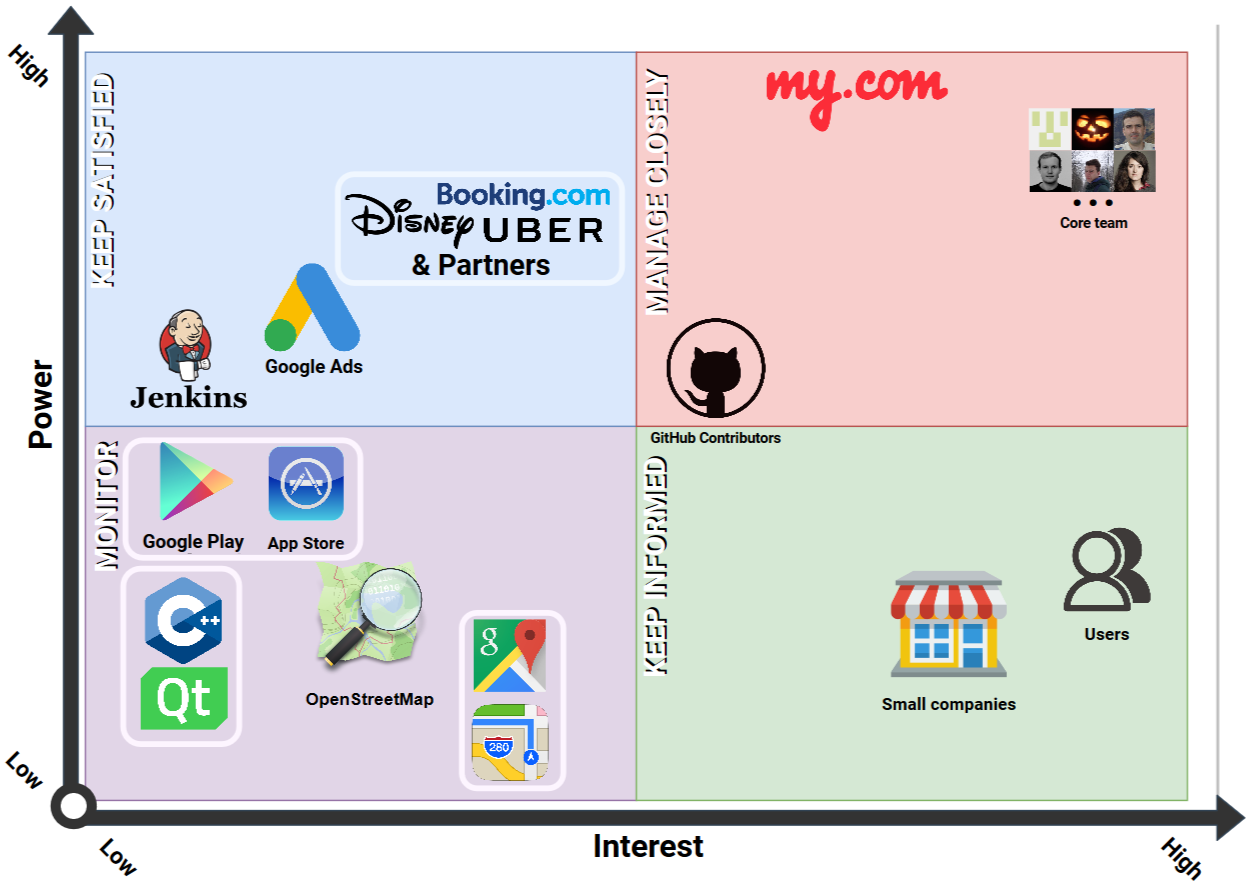
Overall Google’s position does not allow it to assume a position that can be strongly detrimental to MAPS.ME. Google Ads does have power by means of providing ad revenue, however MAPS.ME has other sources of income as well. The app stores have the power to lower the search ranking of MAPS.ME, however, they currently do not appear to lower MAPS.ME in the search ranking as it even considered to be an ‘Editor’s Pick’. Finally, there is no connection between Google Maps and MAPS.ME, which results in it having low power.
All in all, MAPS.ME has established a relatively independent position in its market, in which their most significant concerns revolve around keeping their sources that generate revenue satisfied and maintaining their user base.
Pull Request Analysis
We analyzed 20 pull requests in order to gain insight into the decision-making process of the integrators involved in the project. We picked the 10 merged and rejected (closed) pull requests with the most comments, as these enabled us to give insight into the communication and workflow of the project. The entire analysis can be found in Appendix 1, but this section will provide the conclusions that were made after looking at these pull requests.
The 20 pull requests were all very similar in terms of communication. Lots of decisions are made in some other way than using GitHub communication. These pull requests are either merged or rejected without any clarification, or with a message, for example “discussed on Gitlab”. Most of the discussion being done on the pull requests revolve around code quality on file level. It is rare to see anything else, and when it happens it is often optimization proposals.
The code quality is looked after very well, with one pull request having 800 comments discussing not much else. The proposed changes include fixing or improving code conventions, grammar, and redundancy in the code. Strangely, this does not include documentation of the code or corresponding comments. This gives the impression that the contributors care lots about code quality, but not documentation. Additionally, they rarely seem to question the choice of implementation. This might imply that decisions concerning implementation are made using other platforms of communication. On top of the disregard for documentation, there also seems to be a disregard for testing. Testing is often ignored in pull requests, or postponed initially and ignored afterward.
Bykoianko is the most active in pull requests, as such he appears to be the project leader. However, the Linkedin accounts of the MAPS.ME team reveal that Rokuz has the role of project leader and Bykoianko the role of senior developer.
A significant group of other contributors write their reviews in Russian. In contrast, all commit messages, comments, and language used in the code are English.
Integrators
Based on the analysis of pull requests, the main integrators of the project, and their decision-making strategies are described below. This analysis is key for understanding the interaction of people and developers within the project.
Roman Kuznetsov (Rokuz)
Rokuz interacts in an almost
product owner way. He reviews more than
he contributes. When he opens a pull request, it is often without description and
quickly merged after not more than one approval. If he approves a pull request,
no other approvals are needed. His approvals are often given without
any visible feedback on the contribution.
Contact: N/A
Vladimir Byko-Ianko (Bykoianko)
Bykoianko seems to be one of the most important
people on the project. He either
implements a feature or reviews it in depth. Important decisions on performance
and how features get implemented are made by him.
He is also one of the biggest contributors at the moment.
Contact: N/A
Maxim Pimenov (Mpimenov)
Mpimenov seems to be
fulfilling the quality control role in
the project. He comments on pull requests with mostly proposed style changes,
or hard to miss bugs, which almost always get immediately fixed by the
proposer of the change.
Contact: N/A
Maksim Andrianov (Maksimandrianov)
Maksimandrianov is a relatively new
integrator of the project, however, is allowed to merge.
He often partakes in the review process of features made by others.
Contact: Maksimandrianov1@gmail.com
Tatiana Yan (Tatiana-yan), Vlad Mihaylenko (Vmihaylenko), and Gmoryes
Tatiana-yan and
Vmihaylenko,
seem to fulfill the quality control role next to their developer role.
Gmoryes is one of the new contributors to the
project, having started on it half a year ago. The review process of his pull
requests tend to be longer than others because more faults are present in his code.
Contact: N/A, vxmihaylenko@gmail.com, and N/A.
Context View
The context view describes the relationships, dependencies, and interactions between the system and the environment [25]. The context view of MAPS.ME can be found in Figure 2. The elements in the context view are extracted based on stakeholders, build dependencies, development dependencies, and observing the project repository on GitHub.
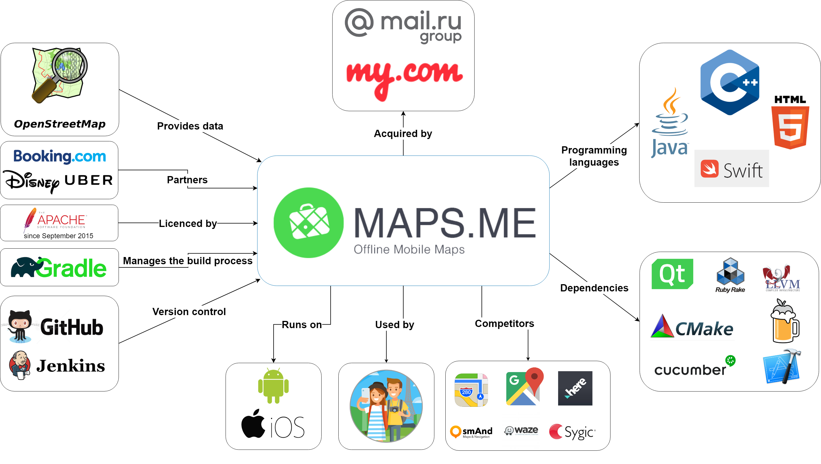
MAPS.ME works differently than most popular navigation applications. Instead of using an internet connection to retrieve and show maps in real time, the application is fully offline. This appeals to a different user group. These users are often travelers or citizens that live in an area with a bad internet connection. This gives the application a valid competitive position compared to other map services, most importantly Google Maps and Apple Maps. This position is important because the app is used on Android and iOS, which are owned by Google and Apple respectively.
To properly build apps for these platforms, Java, Swift, and some third-party applications are used. HTML5 is used for the website and C++ for feature- and main development. The Android module is built with Gradle, the project uses GitHub for version control, and Jenkins as continuous integration service.
An important external entity is OpenStreetMap. OpenStreetMap is an external system to the project which provides the project with crucial map data. Map data of OpenStreetMap is crowdsourced from scratch and changes to maps can be made from within the MAPS.ME apps when an OpenStreetMap account is linked. Besides the points of interest provided by OpenStreetMap, Booking.com adds hotels to the maps, with functionality to directly book a room through the MAPS.ME app.
MAPS.ME is owned by My.com, which is part of the Mail.ru group. Maps.me used to be closed source and a paid service until it got bought by Mail.ru, after which it went open source. It now uses the Apache software license for open source projects.
Scope and Responsibilities
MAPS.ME is an offline navigation app. Its main responsibilities are showing map data properly without an internet connection, providing routing functionality for its users, and showing information on local shops, traffic, transport, and tourist information. Users can also use their GPS to see their location on the maps whilst being offline. The app covers the entire world, as it uses OpenStreetMap data. To prevent the app from taking an immense amount of storage on the device by storing the map files for the world, the separate map files for areas should be handpicked and downloaded by the user beforehand.
The app has some integration with parties such as Booking.com, to add functionality for users and create a revenue stream for my.com. The advertising focuses on travelers mostly and the app lets businesses advertise themselves inside it. The app is free to use, but if the users want an ad-free experience they can pay a subscription fee. It is only available for smartphones, so other more “classic” navigation devices and computers/laptops are outside of the scope.
Development view
The purpose of the development view is to provide insight into the code structure, dependencies and code standards [25]. This helps software engineers work with the system efficiently and in a way that does not violate technical integrity constraints. As of 2nd of March 2018, the repository contains about 46000 files and 5000 directories, totaling 7 GB. This is large enough to make orientation non-trivial.
Module structure
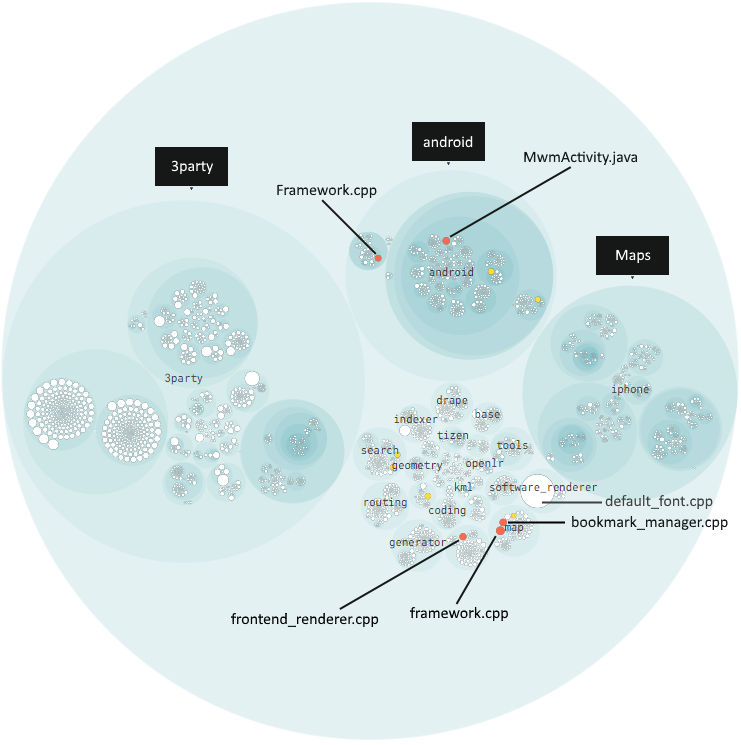
The 5000 directories of MAPS.ME can be structured in modules. The function of these modules and important dependencies between them are shown in the Figure 3. The module structure reveals how important components of MAPS.ME’s architecture work together. No official module structure has been documented in the MAPS.ME repository.

The code is separated in different frames based on their functionality. The Maps frame includes the functionality related to creating and loading the map files (.mwm files) used by MAPS.ME. The Dependencies frame contains a broad generalization, as the so-called “3party” module contains 30 different third-party dependencies. Qt is shown separately, as it has its own folder in the main folder. All the dependencies and map files are used by code in the “Core” frame.
The End-user functionality provides functions like routing, searching for streets and businesses, and live traffic information. Business logic contains (among others) ads, code to process business partners, and a benchmark tool. The GUI contains everything needed to render and display the graphics of the app.
The core is compiled using Cmake. This creates resources from the separate functionalities in the core frame, which are used by the Android and iPhone projects. These projects create the final product in the form of apps. Some improvements can be made to this structure and data flow, which are discussed in Appendix 2.
Common design
Ideally, anyone who contributes to a software system contributes in a way that is consistent with the existing code base. This includes aspects such as a common coding style, standardizing test requirements, and the use of design patterns to improve cohesion. Unfortunately, the project’s idea of a common design appears to be limited.
Common processing
The generator module is a map building tool used from a lot of other modules. According to the README file [14] “For development, use MAPS.ME Designer app along with its generator tool: these allow for quick rebuilding of style and symbols (…)”. Furthermore, no explicit design patterns or contracts that should be adhered to are mentioned in the repository. Most of the functionality that is processed in a uniform manner appears to be incidental or as a result of the system’s implicit constraints.
Common language
Formally the MAPS.ME repository uses English for its documentation and code, whereas discussions on GitHub are often held in Russian [19]. The latter makes it hard for non-Russian speakers to participate.
Coding style
The coding style [15] has been extensively documented in the MAPS.ME docs. For C++ Google’s coding standard [9] is used, with a number of exceptions. For the coding style, ClangFormat [4] is used with a specified configure file. On top of this, a piece of example code has been added.
For map files, MAPS.ME uses an adapted version of MapCSS [22]. A description of this format is not specified. However, a MAPS.ME specific designer app has been built which allows anyone to quickly build maps in a standardized way.
Standardization of testing
Documentation on the standardization of testing is very limited. Within the coding style document, it is mentioned that code should be covered with unit tests. It is also mentioned that third-party libraries should be avoided if they are not fully tested on the MAPS.ME platform. In practice, the amount of testing done is limited and not standardized.
Codeline model
The codeline model describes the source code structure, release process, configuration management, and build and testing approaches [25].
Source Code Structure
There are 49 folders in the root directory of the MAPS.ME project [29]. An overview with descriptions of the source code structure of MAPS.me is given in Figure 4. The descriptions are extended descriptions from CONTRIBUTIONS.md. One contribution to MAPS.ME by us was the addition of missing folder descriptions. As this repository consists of hardly any documentation and comments, it is hard to find out the purpose of each directory in the root folder. Therefore, not every change was accepted in our pull request #10513. Each white description in the figure was already present in the MAPS.ME documentation. The other colored descriptions were (trying to be) added in the pull request. Descriptions indicated in red were not accepted by Mpimenov [21], an author of the project. An elaboration on what information was missing was not given. Descriptions indicated in yellow were partially wrong, green descriptions are accepted and can now be found in the MAPS.ME documentation. Note that the “Core” described in this figure is different from the “Core” described in the Module structure. The Core in this figure was taken from the MAPS.ME documentation while the “Core” in the Module Structure was specified by us as it contains the core functionality.

Build Approach
MAPS.ME has various build procedures. CMake is used as C++ compiler tool to create releases for Android and iOS. The build automation system Gradle is used for the Android version and the iOS version can be built within XCode. The project is developed on MacOS, so building on Linux based systems like Ubuntu will also easily work. However, building on Windows is not supported by the project.
Release Process
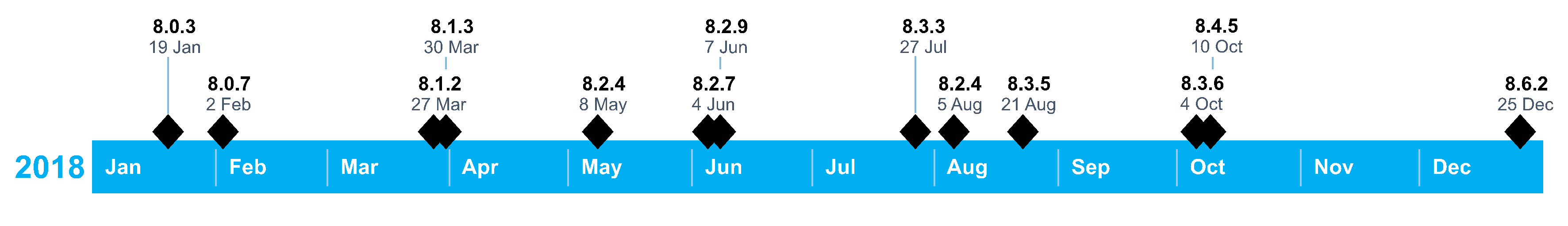
The source code is released on GitHub by merging open pull requests directly to the master branch. Since the real release of builds happens in the Google Play Store and Apple’s App Store, failing builds on the master branch are not as critical as is the case for some other projects. MAPS.ME only had thirteen releases in 2018 [1]. This is a slow deployment cycle compared to other actively developed apps. This could be justified by the fact that resources, such as maps and interesting points on the maps are updated independently of the app. Map updates, with new routes and locations, can be downloaded from within the app. A timeline of the app releases in 2018 can be found in Figure 5. The year 2018 is chosen to give an overview of an entire year of releases. It is noticeable on the timeline that some releases are followed quickly by another release. That could suggest that they did ship some bugged releases, which needed to be patched quickly. The update notes on the Google Play Store do not show that these releases contain bug fixes.
Code management
MAPS.ME uses a Pull-based Software Development Model [10]. Contributors other than the authors have to fork the repository and create pull requests to merge their contributions into the project. Before someone can contribute to the project, a Contributor License Agreement has to be signed [16]. The authors themselves create pull requests but do not provide a description most of the time. If a description is provided, it is often in Russian. Jira is used as issue and bug tracking system but this tool is not available to the public. On some pull requests, the Continuous Integration system Jenkins is used. Jenkins has to be started manually by commenting on a pull request with “JTALL” (Jenkins Test All). In that case, Jenkins tries to build the project for Mac, Android, Linux, and iOS. The details of Jenkins build info cannot be viewed, as these are stored on a private website.
Information View
In this view, we will consider the information- storage, structure and quality. One of MAPS.ME’s main functions is to make map data insightful for end-users. Therefore, we consider the maps and map enrichment data. The map data is used to generate the polygons and so-called ‘features’ which are present on the maps. The map enrichment contains files like translations, style sheets and country metadata.
Information storage
For maps, data is retrieved from OpenStreetMap database [23] using some download utility files in the storage module - as depicted in the module structure. This downloaded data is processed into map files (‘.mwm’) via the ‘generate_mwm.sh’ script, which are stored as flat files on the MAPS.ME server.
The map enrichment files are all included on GitHub and shipped with the app. They are stored in the corresponding formats. For key-values stores ‘.txt’ and ‘.json’ files are used.
Information structure
The information structure we will elaborate on revolves around map data, which uses ‘map enrichment’ files. The statistics are not related to the map and enrichment data.
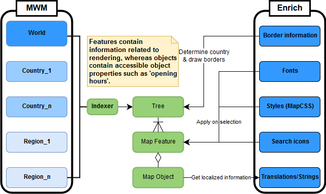
Figure 6 shows how static map- and enrichment files are used in creating the tree of map features that are used by MAPS.ME’s core code. These trees are generated from .mwm files whose granularity depends on the location and level of zoom. If someone zooms in on a specific country, the .mwm file related to that country will be used. Only the ‘.mwm’ file for the world view is included on GitHub and the mobile application by default. Specific map files can then be downloaded from within the app. This can be done by country or specific regions within this country.
The tree contains objects called map features. Each map feature consists of a specific type. There are numerous types, such as schools, industrial land, and pubs. These types contain geometry information, such as polygons, which is used to render them on the map. Some of these types may include a map object, which (generally) function as objects the user can interact with by means of the end-user functionality, as depicted in the module structure.
The features and objects in the tree use the enrichment data in different ways. The border information is used in many ways, most notably to determine the country features belong to and to draw borders. The fonts, style sheets, and search icons are applied to map features on a selection basis, similar to how CSS works. Finally, map objects use translation dictionaries to make strings location-specific.
Information quality
Information quality is warranted by using OpenStreetMap and having the project be accessible for contributions on GitHub. The map data used from OpenStreetMap is crowdsourced and open to adjustments. The data can always be updated to correspond with the real world, as OpenStreetMap updates its files every minute. This prevents users from getting annoyed by outdated data. This undermines the quality of the information slightly. However, if need be, this can be mitigated by releasing more often.
Technical Debt
Technical debt is the term introduced to indicate to nontechnical stakeholders
the need for ‘refactoring’ [11]. From the original description, technical
debt is described as “not quite right code which we postpone making it right”[5].
In this section, analysis tools are used to
identify such technical debt. All analyses ran on the most recent version of the
master branch at the time of writing this section (commit
1931f0f).
Maintainability
First, this section focusses on the maintainability of the project. Low maintainability could lead to surprises in cost and time when change is required [3]. One way to help identify maintainability of code is by the use of SonarQube. SonarQube is a static analysis tool capable of analyzing projects for bad practices, code smells, and more. Thanks to its extensiveness, it enables thorough analyses. As the MAPS.ME project is fairly big, the maintainability analysis will be narrowed down to the Android module.
SonarQube dashboard
From the SonarQube analysis dashboard 230 suspected bugs and 63 vulnerabilities can be found. Furthermore, in Figure 7 can be seen that the number of code smells is excessive (1.6k). Upon manual inspection, the bugs, vulnerabilities, and code smells are in many cases significant. Although there are indications that code smells do not always directly affect maintainability [26, 28], they are good indications of bad practices.

Figure 8 shows the maintainability scores found by SonarQube. The majority of classes fall within 500 lines of code per class and a technical debt below 3.5 hours. The red cluster around seven hours of technical debt mostly contains Activity classes. Most red classes are caused by having far more parent classes than authorized (e.g. 12 parents where 5 is allowed).
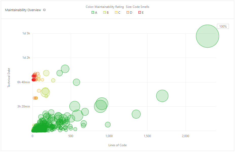
The biggest outlier, with a technical debt of 1d 4h, is MwmActivity.java.
By inspecting the class it becomes clear that this is the main
activity of the application with many functionalities cramped into it and most
of its code being abandoned code.
This emphasizes the need for refactoring this file.
Bad practices
If we look at the complexity of methods in the whole project, some functions
undoubtedly are refactoring candidates. For example,
normalize_unicode::NormalizeInPlace has an NLOC (# lines of code) of 4571 and a Cyclomatic Complexity of 4234.
This was only one of the most extreme cases, beyond doubt there are many more
functions with a complexity even above a hundred. Most of these files are
also identified (see Figure 9) by CodeScene, a static analysis tool capable of
identifying refactoring candidates.
The technical debt on these files can become
a concern if the code is not commented. If we look at the
Android /src module, we see a comment/NLOC-ratio of 3.5% (measured with
cloc).
Compared to the average ratio found by Pascarella and Bacchelli[24], 40%, this
is far lower than most prominent Java repositories. For C++ files, the comment
ratio is 11.7%. Such low comment ratios make it harder to understand the code.
Open source projects without adequate documentation are inherently at a
disadvantage [12].
However, the core team does not seem to give a high priority to commenting or
documentation. Contribution to the documentation was also partly rejected and
the core team would rather postpone updating the documentation
(see #10513). The obvious solution
to the technical debt in maintainability is to add documentation to the code and
reduce the Cyclomatic Complexity in the identified refactoring candidates.
Testing debt
MAPS.ME does not use a standard testing framework. There are unit tests, but these can only be executed by their own test execution code [20]. This has some major disadvantages, which will be elaborated upon in this subsection.
Tests do not have IDE support, so executing tests can only be done from a terminal and results can only be viewed in a log file. This becomes a problem when a test fails, as it takes effort to find the cause. The script which executes tests, executes the test binaries separately, so there is no conclusive result of all tests. Failing tests are hidden between different modules in the generated log file.
The authors did not implement a way to measure code coverage into their testing module, so there is no easy way to tell which parts of the code are tested and which are not. This makes it very hard for us to discuss well- and less tested modules. When asking for more clarification on measuring code coverage in an issue #10555, we did not get any response as of writing this section.
To observe current testing behavior, we analyzed the last fifty pull requests to the project, which is a little more than a week of contributions. Of the fifty pull requests, only 12% changed test files. This indicates a significant testing debt.
Several actions should be taken to decrease further testing debt. As all main authors are developing in Xcode, the testing framework XCTest could be used to create and run unit tests, performance tests, and UI tests. This enables developers to debug tests, see code performance, measure code coverage, and automate testing.
Self-admitted technical debt
Technical debt is often introduced knowingly by developers, often indicated with “TODO”s, “FIXME”s or “BUG”s in the code. To find how many of these markers are present in the project, we used todo-show for Atom. This package allows to count and filter for the indications. The code contains a total of 2384 TODOs, 552 FIXMEs, and 19 BUGs.
A considerable part of the project is the code for the Android app. When building the Android app, the C++ compiler shows (600+) unhandled warnings. These warnings indicate potential issues. Either these warnings should be suppressed, or the code should be adjusted accordingly.
The total amount of markers in the code and the number of compile warnings give the impression that the code contains a hefty amount of self-admitted technical debt. As Storey et al. [27] have shown, developers believe that TODOs and other similar markers have a significant negative effect on the maintainability of the project. To avoid this technical debt, the developers should solve the warnings and identify the most important indicators.
Evolution of technical debt
To measure the evolution of technical debt, we analyzed the interactions of the integrators. The way they handle situations concerning technical debt can be an interesting benchmark. Often new features get merged without the mention of tests or even the added TODOs in the code. Occasionally, the integrators add tests for the most important functionality. In discussions around only a few pull requests, tests and comments are emphasized.
The last time a TODO was actually implemented was almost three years ago. The way of communication and implementation imply that the integrators ignore the technical debt of the project. They often add code containing technical debt and rarely discuss it. This causes the technical debt to keep growing and go unchecked.
Impact
With high Cyclomatic Complexity and the marginal documentation in the code, contributing to the project gets increasingly hard. The original author may be gone and, therefore, knowledge about functionality may be lost. Mistakes are more likely to be made, as confusion is dragged through the project. As the project has hardly any tests and the framework used for testing is incomplete, it is likely that many defects remain unnoticed. The defects and missing components that are noticed, e.g. with a TODO, are mostly ignored. After years of ignoring the indicators, the absence of their implementation can possibly cause extensibility problems or defects.
Conclusions
The conclusions reflect on the purpose of this chapter, which was to assess the quality of MAPS.ME with respect to the different software architecture viewpoints.
With respect to the context view and the stakeholders, MAPS.ME is a project which has a strong market position as an app. The emphasis on offline navigation allows it to separate itself from its competitors and its target audience is big enough to attract funders. Furthermore, MAPS.ME is not dependent on stakeholders which might have the intent to inhibit the project.
For the development view, MAPS.ME has a lot of room for improvement. The concerns of modules within the module structure are not always clearly separated. It is not easy to figure out the responsibility of modules, because the codeline structure is highly fragmented and there is little documentation. MAPS.ME could improve this aspect by including documentation about the data flow and the module structure. Also, better grouping the directories according to their functionality would improve MAPS.ME.
For the information view, MAPS.ME’s dependence on OpenStreetMap allows it to keep its map data up-to-date. The information and related modules are well-structured. All in all, this makes MAPS.ME’s approach for handling map data solid, yet relatively simple.
According to manual and automated analysis, we identified a significant technical debt. SonarQube revealed a high technical debt and low maintainability. A lot of this technical debt is self-admitted and has been shown to not reduce over time. The testing debt was not easy to measure. Having a uniform testing framework could help MAPS.ME control their tests better. In order to improve this aspect, the core team should become aware of the consequences of high technical debt and how to deal with it. Static analysis tools could help with gaining such insight.
One particular theme among the different subsections of this chapter is the communication between the core team and the GitHub community. The project does not contain sufficient documentation to understand the code. The core team also does not respond hospitably when asked questions. Furthermore, the vast majority of the contributions are done by the core team without any reviews from external developers. As a result, it is hard to consider MAPS.ME a truly open source project.
References
[1] APKPure. 2019. MAPS.ME update version history for android - apk download. Retrieved March 22, 2019 from https://apkpure.com/maps-me-%E2%80%93-offline-map-and-travel-navigation/com.mapswithme.maps.pro/versions
[2] Apple. 2018. Apple media services terms and conditions. Retrieved March 22, 2019 from https://www.apple.com/legal/internet-services/itunes/us/terms.html
[3] T. Bakota, P. Hegedűs, G. Ladányi, P. Körtvélyesi, R. Ferenc, and T. Gyimóthy. 2012. A cost model based on software maintainability. In 2012 28th ieee international conference on software maintenance (icsm), 316–325. DOI:https://doi.org/10.1109/ICSM.2012.6405288
[4] Clang. Clang 9 documentation. Clang C Language Family Frontend for LLVM. Retrieved March 22, 2019 from https://clang.llvm.org/docs/ClangFormat.html
[5] Ward Cunningham. 1992. The wycash portfolio management system. SIGPLAN OOPS Mess. 4, 2 (December 1992), 29–30. DOI:https://doi.org/10.1145/157710.157715
[6] GitHub. Contributors to mapsme/omim. Retrieved March 22, 2019 from
https://github.com/mapsme/omim/graphs/contributors
[7] Google. 2018. Google play terms of service. Retrieved March 22, 2019 from
https://play.google.com/about/play-terms/index.html
[8] Google. MAPS.ME – offline map and travel navigation - apps on google play. Retrieved March 22, 2019 from https://play.google.com/store/apps/details?id=com.mapswithme.maps.pro
[9] Google. Google c style guide. Retrieved March 22, 2019 from https://google.github.io/styleguide/cppguide.html
[10] Georgios Gousios, Martin Pinzger, and Arie van Deursen. 2014. An exploratory study of the pull-based software development model. In Proceedings of the 36th international conference on software engineering, 345–355.
[11] P. Kruchten, R. L. Nord, and I. Ozkaya. 2012. Technical debt: From metaphor to theory and practice. IEEE Software 29, 6 (November 2012), 18–21. DOI:https://doi.org/10.1109/MS.2012.167
[12] Michelle Levesque. 2004. Fundamental issues with open source software development. First Monday 9, 4 (2004). DOI:https://doi.org/10.5210/fm.v9i4.1137
[13] MAPS.ME. 2015. Mapsme/omim contributors. Retrieved March 22, 2019 from
https://github.com/mapsme/omim/blob/master/CONTRIBUTORS
[14] MAPS.ME. 2018. Mapsme/omim readme. GitHub mapsme/omim. Retrieved March 22, 2019 from
https://github.com/mapsme/omim/blob/master/README.md
[15] MAPS.ME. 2018. Mapsme/omim coding style. Retrieved March 22, 2019 from
https://github.com/mapsme/omim/blob/master/docs/CPP_STYLE.md
[16] MAPS.ME. 2019. Mapsme/omim contributing.md. Retrieved March 22, 2019 from
https://github.com/mapsme/omim/blob/master/docs/CONTRIBUTING.md
[17] MAPS.ME. Partners. Partners. Retrieved March 22, 2019 from https://maps.me/partners/
[18] MAPS.ME. MAPS.ME – support. Retrieved March 22, 2019 from https://support.maps.me/hc/en-us
[19] MAPS.ME. Pull requests mapsme/omim. Retrieved March 22, 2019 from
https://github.com/mapsme/omim/pulls
[20] MAPS.ME. Mapsme/omim testing tree github. Retrieved March 22, 2019 from
https://github.com/mapsme/omim/tree/master/testing
[21] mpimenov. mapsme/omim Pull request #10513. 2019. Retrieved March 22, 2019 from https://github.com/mapsme/omim/pull/10513#pullrequestreview-213079484
[22] OpenStreetMap. MapCSS. About OpenStreetMap - OpenStreetMap Wiki. Retrieved March 22, 2019 from https://wiki.openstreetmap.org/wiki/MapCSS
[23] OpenStreetMaps. API. API - OpenStreetMap Wiki. Retrieved from https://wiki.openstreetmap.org/wiki/API
[24] L. Pascarella and A. Bacchelli. 2017. Classifying code comments in java open-source software systems. In 2017 ieee/acm 14th international conference on mining software repositories (msr), 227–237. DOI:https://doi.org/10.1109/MSR.2017.63
[25] Nick Rozanski and Eoin Woods. 2012. Software systems architecture: Working with stakeholders using viewpoints and perspectives. Addison-Wesley.
[26] D. I. K. Sjøberg, A. Yamashita, B. C. D. Anda, A. Mockus, and T. Dybå. 2013. Quantifying the effect of code smells on maintenance effort. IEEE Transactions on Software Engineering 39, 8 (August 2013), 1144–1156. DOI:https://doi.org/10.1109/TSE.2012.89
[27] Margaret-Anne Storey, Jody Ryall, R. Ian Bull, Del Myers, and Janice Singer. 2008. TODO or to bug: Exploring how task annotations play a role in the work practices of software developers. In Proceedings of the 30th international conference on software engineering (ICSE ’08), 251–260. DOI:https://doi.org/10.1145/1368088.1368123
[28] Min Zhang, Tracy Hall, and Nathan Baddoo. 2011. Code bad smells: A review of current knowledge. Journal of Software Maintenance and Evolution: research and practice 23, 3 (2011), 179–202.
[29] MAPS.ME tree github. Retrieved March 22, 2019 from https://github.com/mapsme/omim/tree/master/
Appendices
Appendix 1: Full Analysis of Pull Requests
Pull request
Title + ID: [generator] Added wikipedia descriptions generation.
#9811
Lifetime: Nov 9, 2018 - Dec 3, 2018
Components: generator/generator_tool, indexer
Created by: Maksimandrianov
Accepted/Rejected: Accepted
Merged by: Mpimenov
Addresses: Feature
Issues: N/A
Deprecates pull-request: N/A
This pull request adds a feature which allows the generation of descriptions for map elements on the basis of the Wikipedia API. Tests were included in this pull request. This is a feature which users of the system would want and the code was deemed to be of sufficient quality. A number of different people suggested minor changes to which Maksimandrianov responded with “++”. There were also comments regarding more structural concerns, these were also responded to and addressed by Maksimandrianov.
Pull request
Title + ID: [routing] Add speed cameras to routing + tests
#9405
Lifetime: Sep 5, 2018 - Sep 17, 2018
Components: routing: speed_camera, map
Created by: Gmoryes
Accepted/Rejected: Accepted
Merged by: Bykoianko
Addresses: Feature
Issues: N/A
Deprecates pull-request: N/A
This feature adds a component displaying a UI icon and voice warning if a user approaches a speed camera. Tests were included in this pull request. This is a feature which users of the system would want and the code was deemed to be of sufficient quality. Bykoianko and Mpimenov gave the most feedback to which Gmoryes responded with ‘done’ or replied with a longer response which resulted in some discussion. The feedback consisted of a mix of structural feedback and some minor changes.
Pull request
Title + ID: [routing] Fix crash because of transit id
#10181
Lifetime: Jan 9, 2019 - Jan 10, 2019
Components: routing:corss_mwm_index_graph.hpp (Single file)
Created by: Gmoryes
Accepted/Rejected: Rejected
Closed by: Gmoryes
Addresses: Bugfix
Issues: N/A
Deprecates pull-request: N/A
This PR attempts to fix one equality assignment related to segment geometry. Closed because the integration tests fail and a fix was released in another version. Gmoryes and Bykoianko discussed the proposed fix in detail. In this discussion Bykoianko mentioned an alternative way to fix the issue, which involved using different methods touching different parts of the program. Bykoianko also explained why this might be beneficial.
Pull request
Title + ID: Persian translation
#9558
Lifetime: Sep 29, 2018 - Oct 8, 2018
Components: iphone/Maps/LocalizedStrings, data/strings
Created by: Mnameghi
Accepted/Rejected: Rejected
Closed by: Mpimenov
Addresses: Translation
Issues: N/A
Deprecated by pull-request: #9360
This PR adds Persian translations to MAPS.ME. Closed because there were some minor issues which were addressed in a different PR (#9630). This different PR, made by Tatiana-yan, was merged. A number of people said it looked good and thanked Mnameghi. Mpimenov gave a lot of feedback in terms of some characters or quotes which should be removed.
Pull request
Title + ID: [generator] Region kv iso3166-1
#9349
Lifetime: Aug 23, 2018 - Sep 4, 2018
Components: generator: region files
Created by: Maksimandrianov
Accepted/Rejected: Closed
Closed by: Maksimandrianov
Addresses: Feature
Issues: N/A
Deprecated by pull-request: #9393
Adds regions to the generator. After not a lot of substantial suggestions, Tatiana-yan suggested a rebase after which Maksimandrianov closed it without further explanation. A pull request addressing the same issue was opened on 4 September 2018. This pull request was merged, however no mention to #9393 was ever given.
Pull request
Title + ID: [generator] Region kv
#9340
Lifetime: Aug 21, 2018 - Sep 3, 2018
Components: Generator/regions
Created by: Maksimandrianov
Accepted/Rejected: Accepted
Merged by: Mpimenov
Addresses: Feature
Issues: N/A
Deprecates pull-request: #9349
This pull request adds regions to the generator such as city, town, village, suburb, and neighborhood. The three reviewers of this pull request are Mpimenov, Tatiana-yan, and Syershov. There is a discussion going on if a certain third party application should be included in the codebase or not. There are also some grammatical and format errors addressed. Furthermore, code efficiency is improved after reviewing. Also, tests are added after the pressure of the reviewers. The pull request is accepted after a lot of conversation (377 comments in total), where code quality is vastly improved and bugs are solved together.
Pull request
Title + ID: [routing] SpeedCameras Core and ios interface
#9888
Lifetime: Nov 22, 2018 - Nov 30, 2018
Components: Implementation and interface of speed cameras on iOS
Created by: Gmoryes
Accepted/Rejected: Accepted
Merged by: Bykoianko
Addresses: Feature
Issues: N/A
Deprecates pull-request: N/A
This pull request has no description. It adds speed cameras to the interface of iOS and also adds the implementation of speed cameras. The reviewers Vmihaylenko and Bykoianko are addressing format and style improvements. It is finally approved after a conversation of 202 comments. Many inconsistencies, style issues, and small refactors are addressed.
Pull request
Title + ID: [DNM][traffic] Switching off temp blocking traffic jam for Russia.
#10060
Lifetime: Dec 13, 2018 - Dec 14, 2018
Components: traffic
Created by: Bykoianko
Accepted/Rejected: Rejected
Rejected by: Bykoianko
Addresses: Bugfix
Issues: N/A
Deprecates pull-request: N/A
Deprecated by pull-request: #10078
This pull request is closed quickly because Burivuh wants that the code is added to master directly. The new pull request #10078 is discussed later on.
Pull request
Title + ID: [DNM] http thread refactoring
#10043
Lifetime: Dec 11, 2018 - Dec 12, 2018
Components: http_thread
Created by: Beloal
Accepted/Rejected: Rejected
Closed by: Beloal
Addresses: Refactoring
Issues: N/A
Deprecates pull-request: N/A
This pull request is a refactoring of HTTP thread classes. The refactoring is said to be bad by Maksimandrianov, Mpimenov, and Rokuz, as the refactoring introduces a lot of typecasting. The author of the pull request does not agree with this and closes the pull request as he thinks there is no further reason to discuss this matter. A similar solution intended by this refactor is implemented in pull request #10047 and self-merged by Beloal, this time with changes accepted by Rokuz and Vmihaylenko.
Pull request
Title + ID: Remove duplicates from strings.xml
#9789
Lifetime: Nov 4, 2018 - Nov 6, 2018
Components: strings
Created by: Dimqua
Accepted/Rejected: Rejected
Rejected by: Rokuz
Addresses: Translation
Issues: N/A
Deprecates pull-request: N/A
Deprecated by pull-request: #9768
This is a small pull request which removes a duplicate string from the translations for the Android app. The pull request is closed by Rokuz because this particular string is already removed in an earlier pull request #9768.
Pull request
Title + ID: Maxspeed section.
#9697
Lifetime: Oct 18, 2018 - Nov 23, 2018
Components: generator maxspeed, routing
Created by: Bykoianko
Accepted/Rejected: Accepted
Merged by: Mpimenov
Addresses: Feature
Issues: #9697
Deprecates pull-request: N/A
The pull request adds a section to the application which holds information on speed limits of roads, saved with a “maxspeed” tag. The purpose seems to be the addition of a major feature. This pull request is the first pull request containing code related to this feature.
The process starts with the initiator (Bykoianko) asking for reviews of three other contributors: Vmihaylenko, Mpimenov, and Maksimandrianov. A different contributor joins in and discusses the implementation of a very specific method in the code, resulting in the initiator changing the code as proposed. All of the invited contributors propose several optimization changes, which are quickly accepted and implemented by the initiator. Mpimenov seems to adhere to a form of commenting which is as follows: s/x/y/, where the s/…/ implies x should be changed to y. Tens of bugs seem to be fixed by other contributors proposing changes. After many bugfixes, the reviewers approve the pull request one by one with no further clarification except for “LGTM” (looks good to me).
Noteworthy is that the initiator seems to use triggers for automated checks of the code. One of such triggers is “JTA”, of which the purpose is unclear.
Pull request
Title + ID: New IndexGraphStarterJoints, JointSegment, jumps between segments.
#9857
Lifetime: Nov 16, 2018 - Jan 23, 2019
Components: routing
Created by: Gmoryes
Accepted/Rejected: Accepted
Merged by: Bykoianko
Addresses: Feature
Issues: #9857
Deprecates pull-request: N/A
The pull request adds a part of a new feature, namely routing based on joints in an effort to improve routing.
The review process starts off with a “JTA” comment by Bykoianko, who joins the review process. He follows by pointing out several flaws in the implementation, and why it is not what he expected when proposing the feature. Some optimization changes are denied by Gmoryes, the initiator of the project because the time saved is not worth the amount of work. Both Bykoianko and Vmihaylenko post various strict comments on the language of the code comments, which need to be switched from Russian to English. After all these changes, and after running integration tests, Bykoianko decides it is good enough and merges the commit.
Pull request
Title + ID: Added geo objects translator.
#9592
Lifetime: on Oct 3, 2018 - Oct 5, 2018
Components: generator
Created by: Maksimandrianov
Accepted/Rejected: Accepted
Merged by: Mpimenov
Addresses: feature
Issues: #9592
Deprecates pull-request: N/A
The pull request is part 1 of 2 and contains a translator that collects houses and points of interest (poi) and a collector that collects houses and poi without an address. This effort is made to increase the number of addresses and poi the app can handle, thus increasing its functionality.
Maksimandrianov starts off by requesting a review from Tatiana-yan, Mpimenov and Syershov. Tatiana-yan immediately asks for tests of the functionality, which seem to go ignored. Mpimenov follows up by suggesting many bugfixes and style corrections. The other contributors follow with similar suggestions. Tatiana-yan asks some more in-depth questions, which are either followed by a revision of the code, or further clarification. She seems to be the main reviewer for this pull request. Short description of interaction/discussion between users. Syershov seems to approve the pull request earlier than any other reviewers, with no apparent reason. After some small changes and a few bugfixes, the other reviewers also approve the pull request.
Pull request
Title + ID: Add speed camera (ROUTING)
#9331
Lifetime: Aug 17, 2018 - Sep 5, 2018
Components: routing
Created by: Gmoryes
Accepted/Rejected: Rejected
Closed by: Gmoryes
Addresses: Feature
Issues: N/A
Deprecated by pull-request: #9330
The pull request is made without any description, however, the title implies it adds a new feature, namely speed cameras. Bykoianko, Vmihaylenko, and Tatiana-yan propose several style changes and bugfixes. Bykoianko notes that there is something wrong with the way GitHub shows the changes. Some more discussion is done on aspects of the new feature, e.g. the notification to the user when a speed camera is close. The pull request is then closed, because as Gmoryes states: “GitHub does not correctly show the changes that already exist in master”. It seems the code in this pull request is still accepted and merged in another pull request, namely #9330.
Pull request
Title + ID: CityBoundariesChecker
#9346
Lifetime: Aug 23, 2018 - Aug 27, 2018
Components: routing
Created by: Bykoianko
Accepted/Rejected: Rejected
Closed by: Bykoianko
Addresses: Feature
Issues: N/A
Deprecated by pull-request: #9361
Bykoianko opens the pull request with a new feature which checks the boundaries of cities. He asks Rokuz, Mpimenov, and Tatiana-yan to review it. Some discussion on the functionality is done, mostly by Bykoianko and Tatiana-yan. Mpimenov proposes several bugfixes and style changes. Rokuz approves the changes without any interaction. Eventually, Bykoianko decides the approach of the implementation is not satisfactory, due to performance reasons. The benchmark shows the load times on android increase by 13 seconds due to this feature. Bykoianko closes the pull requests and redirects the feedback to pull request # 9361, which implements a similar feature in a different way.
Pull request
Title + ID:
[routing] Add speed camera section (GENERATOR)
#9330
Lifetime: Aug 17, 2018 - Sep 5, 2018
Components: routing, routing/speed_camera, generator, translator
Created by: Gmoryes
Accepted/Rejected: Accepted
Merged by: Bykoianko
Addresses: Feature
Issues: N/A
Deprecates pull-request: N/A
The pull requests add the option to have speed camera indications in the routing of the MAPS.ME client. The pull request is a big pull request as it affects 49 different files with around 2000 touched lines. The majority of these affected files were either in the routing package or in the generator package.
Interestingly, the author did not feel the need to explain this feature in his pull request. Moreover, his single commit affecting around 2000 lines also did not have any explanations for his changes. Of all of his changes, a vast majority was added without any comments. Still, the new feature was merged to the master without any complaints about the commenting or committing behavior. Therefore, it seems with this pull requests that none of the reviewers feel the need for any comments for future developers.
Almost all the changes that were requested were mostly concerning the coding style.
For example, the order of imports. The type of remarks was similar for all three
reviewers (i.e. Tatiana-yan, Bykoianko, and Mpimenov).
None of the reviewers mentioned the size of the pull request or the number of files
and components that were touched by it.
The need for the pull request becomes clear when one analyzes some of the competitors (like Google Maps and TomTom), who provide a similar feature for speed cameras. Therefore, the feature becomes clear in the context of a navigation system, where a driver would like to know where speed cameras are. However, the acceptance of the pull request leaves some doubt to the overall code quality of the project, as a clear lack of documentation leaves doubt to the design decisions made.
Pull request
Title + ID: Indexed AStar routing
#4672
Lifetime: Nov 7, 2016 - Nov 26, 2016
Components: routing, routing/geometry
Created by: Dobriy-eeh
Accepted/Rejected: Accepted
Merged by: Bykoianko
Addresses: Feature
Issues: N/A
Deprecates pull-request: N/A
In this pull request, the famous A* algorithm for routing is implemented with the support of indexing to improve the performance of the algorithm. To do so, most of the routing files were affected. In the pull request around 2000 lines were changed of which a significant portion for the addition of new tests.
From all of the 729 comments in the full discussion of the pull request, only three discussions (with a total of 13 comments) were questions (and answers) covering the actual working of the implementation of the algorithm itself. All other comments concerned the code quality, code conventions, missing comments, or missing tests.
Pull request
Title + ID: [routing] Applying restrictions on index graph
#4817
Lifetime: Nov 26, 2016 - Mar 6, 2017
Components: routing
Created by: Bykoianko
Accepted/Rejected: Rejected
Rejected by: Bykoianko
Addresses: Feature
Issues: N/A
Deprecates pull-request: #4998
In this pull request, Bykoianko implements the imposition of restriction on the index graph. This is used to improve the algorithm for route generation. In the pull request, Bykoianko ensures that the reviewers understand his changes by giving examples.
Interestingly, none of the reviewers question the choices in the implementations or the working of the algorithm. Although the implementation is an advanced implementation, the only remarks that are made have to do with the code quality. This raises the question if the implementation is discussed outside the pull request or that no reviewer takes the time to question the algorithm.
In the end, the pull request is suddenly closed with a message that a dynamic restriction was implemented instead. This suggests that there was a discussion going on about the best algorithm to implement but this discussion is nowhere to be found. The alternative pull request (i.e. #4998), that was accepted, also does not contain a discussion nor does it contain a single review. Therefore, the review process is must have been done somewhere else. This could be an external application or in person in Moscow, where the MAPS.ME office is located.
Pull request
Title + ID: [descriptions] Description section serializer and deserializer added.
#9783
Lifetime: Nov 2, 2018 - Nov 23, 2018
Components: descriptions
Created by: Darina
Accepted/Rejected: Accepted
Merged by: Mpimenov
Addresses: Feature
Issues: N/A
Deprecates pull-request: N/A
The descriptions that can be added to elements in the MAPS.ME app can, with this new feature, be serialized and deserialized. This feature is used for the language system that is built into the application to support multiple languages.
As most pull requests, the vast majority of the comments are about the code quality. Interestingly, Darina does not accept all comments right-away. The pull requests contain discussions where Darina does not accept the review that was given and requires the reviewer to further explain his or her requests.
Also, this pull requests shows some evidence of discussions outside GitHub. Darina mentions that she discussed some of the implementation choices with Mpimenov, while there are no indications of discussion on GitHub of the subject.
Bykoianko discovered that the implementation lacked tests, so he asked Darina to add some. She, however, asked to postpone it for a new pull request which was accepted. Multiple reviewers agreed with this decision, which is arguably a bad decision. The chance that the tests will never be added is increased with the decision. Eventually, the pull request is merged with a request for a few changes in a future, undecided, pull request.
Pull request
Title + ID: [DNM][traffic] Switching off temp blocking traffic jam for Russia.
#10078
Lifetime: Dec 14, 2018 - Jan 18, 2018
Components: traffic
Created by: Bykoianko
Accepted/Rejected: Rejected
Rejected by: Bykoianko
Addresses: Feature
Issues: N/A
Deprecates pull-request: #10060
Deprecated by pull-request: #10210
According to Bykoianko, a temporary switch-off is required to not show temporary traffic blocking due to traffic jams. The feature only supports traffic jams in Russia.
The discussion for the pull request is short and abruptly stopped with the announcement that the pull request will be closed for an alternative. The decision was made to shift the implementation, which was client-side, to a server-side implementation. Three weeks later the alternative was merged. Again, evidence was shown that the developers discuss their concerns outside the pull request on GitHub. Bykoianko posted an URL to a Gitlab, which we could not access. The Gitlab is hosted by a Mail.ru server, which is the owning company of the project. It could, therefore, mean that the Gitlab is a private platform for discussions within the company.
Appendix 2: Possible architecture improvements
When looking at the top level (highly abstract) architecture, some aspects can be improved. For example, the module “3party” contains lots of third party dependencies. These could be implemented in a more structured way by creating third party handler classes (or interfaces) for each type of third party dependency. There could be one for GUI dependencies, one for map data dependencies, etc.
The other parts that are open for improvement are the part we call “Business logic” and the coding module. The “Business logic” part contains a module called “map”. This “map” contains code for all sorts of functionalities, like booking information, gps tracking , cloud storage, user markers, etc. All this code seems to be dumped in this folder with no coherent structure whatsoever. This module could be split up for the different functionalities, and a neat tree like structure could be made for them.
The overall data flow of the project is unclear, as all resources are compiled by cmake, after which they are used by the subprojects for differing platforms. This could be changed, or documentation could be improved to make this clear for new developers.